Into the wilds of Malaga: a hike that tested my limits
- Jul 21, 2025
- 6 min read
Updated: Jul 25, 2025
Today’s excursion promised to be memorable. For the second time this summer, I ventured beyond the familiar province of Cadiz into neighbouring Malaga in pursuit of new terrain and fresh bird sightings. With Andalusian summers typically punishing, I chose this particular day because the forecast offered a small reprieve. Today was supposed to peak at 29°C—hardly refreshing, but manageable.

The plan was straightforward. Starting near the train station at Cortes de la Frontera, I would hike a roughly 13-kilometre trail that included scenic highlights like the Puente de los Alemanes, the Cañón de las Buitreras, and the idyllic Charco del Moro. If I felt strong, I would return by following the same path; if not, I’d peel off toward Gaucín station and ride the train back.

The trail’s first kilometre delivered a sense of peace and promise. A shady, tree-lined path buzzed with birdsong: Iberian Green Woodpeckers, Iberian Chiffchaffs, and Treecreepers filled the air, while Chaffinches darted between branches in lively numbers. The world felt alive, vibrant. Soon I reached Puente de las Pepas, a bridge over the Guadiaro River. The surrounding mountains, the gentle rush of water, and the tranquil atmosphere tempted me to linger. Then, as if summoned, a flock of Bee-eaters swooped down to feed, diving and twisting above the water in an aerial ballet. Alongside them, Grey Wagtails flitted through the shallows, and even a White Wagtail made a surprise appearance. I could’ve watched them for hours, but the trail called.


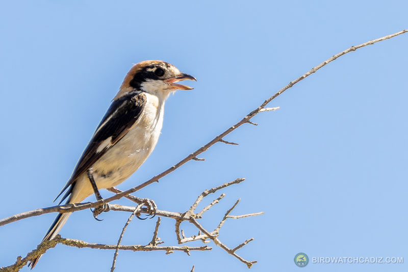
Ascending gradually, I encountered Cirl Buntings, then a Woodchat Shrike, along with more Chaffinches. Though the incline increased, it didn’t weigh heavily on me—at least not at first. But as the heat intensified, my water supply vanished far too quickly. Still, trail markers assured me I was on track.


Earlier this morning, I had debated whether to wear long or short trousers. The longer option would provide protection from thorns, but at the cost of overheating. I’d chosen shorts, betting on comfort. At first, that decision seemed to be the right one. The path was clear, the vegetation friendly. I hadn’t seen a single thorn.

But the further I went, the more the signage began to deteriorate. The original markers—a familiar yellow paint strip—had vanished. Only sparse red and white trail indicators remained. There weren’t many crossroads, so I assumed I was still on the correct trail. Then I passed through a hunting enclosure marked by a gate, which asked hikers to close it behind them. I obeyed, though the clarity of the route was quickly vanishing.

Inside the enclosure, things changed. The trail became erratic. There were no signs now, and the terrain became overgrown with thorny shrubs. My legs began to suffer, scratched and bleeding from constant contact. Still, I pushed on, relying on my phone’s GPS. I later learned I had veered off the correct route and was no longer near the Guadiaro at all. I had followed a different watercourse altogether—an isolated stream called Arroyo del Veranil, which during this time of year was largely dry. Several people later described this area as dangerous due to the overgrowth, poor maintenance, and misleading signage. They weren’t exaggerating.

Though the landscape around me was rugged and starkly beautiful, it became repetitive. The thorny vegetation was unrelenting. Griffon Vultures circled above, but birdlife had largely quieted. The sun was now high, and I was beginning to feel fatigue in a way that concerned me. When I finally saw water in the stream again, I hoped I might be approaching Charco del Moro—but it wasn’t clear.


The trail, such as it was, had dissolved into guesswork. I considered either climbing a steep slope for a better view or descending into the streambed to follow the water. The river seemed shallow, so I gambled on going down, reasoning it might offer both a path and relief from the heat.


I waded carefully. The water was cool and refreshing, and I filled my empty bottle at a narrow, fast-running spot. I knew it wasn’t ideal, but thirst had stripped away better judgment. Every now and then I slipped on algae-slicked stones, but my camera gear remained dry and intact.

Then, unexpectedly, I had company. An otter emerged from the bank and slipped into the stream just ahead of me. It moved gracefully, unbothered by my presence. For a few surreal minutes, we shared the river, side by side. The presence of this wild companion seemed to pull me out of my discomfort, if only temporarily.

Soon after, a White-throated Dipper appeared, hopping between the rocks. It would fly ahead about twenty metres, perch, wait for me, then repeat the process. I began to think of it as a guide, coaxing me forward through the uncertain terrain. I could have lingered to photograph it properly—an ideal subject—but I was in no state for patience. I needed to find a way out.
My condition was worsening. A knee wound had deepened, bleeding persistently. I reached a sheer drop I could not climb down safely. The only option was to turn around, wade back upstream, and somehow find the spot where I had originally entered the river. But the bank was overgrown, and everything looked different in reverse.


I stayed calm, recalling one of the essential lessons from years of hiking: always remember distinct landmarks—stones, branches, peculiar tree shapes. Those memories helped me locate my earlier track and crawl back up onto more solid terrain.

The idea of reaching the Gaucín train station was now a fantasy. I was in no condition to continue, and the direction was completely unclear. My only realistic option was to return to the starting point, ten long kilometres away. Every step scraped more skin from my already torn legs. I found myself involuntarily shouting, yelping in pain every time another thorn lashed my shins.
What had happened to the yellow signs? Had they been deliberately removed? How could anyone be guided safely through this route with such poor marking? My trust in the trail had turned to frustration. I kept walking, relying now on memory, instinct, and pain.

Eventually, the track became more recognisable, more stable. But by then, fatigue had taken over. I hadn't eaten in hours—it had simply been too hot—and I had barely rehydrated. Each uphill stretch felt longer than the last. The sun was punishing, directly overhead. There was no shade, no breeze. I rested occasionally, though each break made restarting harder.
There were still five kilometres to go. Five is not a daunting number under ordinary conditions, but in that moment, under that sun, carrying heavy camera gear, it felt immense. My legs were trembling, my back stiff. Then, as if scripted, I saw a vehicle approaching along the dusty trail. I waved it down and asked the driver if he could help me. Kindly, he agreed, and I climbed in with immense relief. He drove me back to my car, where cold drinks awaited in the trunk. They tasted like salvation. It took time to recover, but the worst was behind me. Thanks a lot, Abel.

This wasn’t my first difficult hike, but it was a strong reminder that even well-researched routes can take a turn. Trails change. Signs disappear. And when they do, calm decision-making becomes vital. Always pack more water than you think necessary. Plan backup routes. And don’t be afraid to turn around when safety demands it. Adventure isn't about stubbornness—it's about making it home to tell the story.


Comments